Daytona Beach Transportation
Visitors can fly non-stop into Daytona Beach International Airport via Delta (from Atlanta, ATL), American Airlines (from Charlotte, CLT) year-round, with additional seasonal service via American Airlines from Philadelphia (PHL), Dallas/Ft. Fort (DFW) and Washington Reagan National Airport (DCA) and via Avelo Airlines (New Haven, CT, HVN and Wilmington, DE, ILG). Check out our area airports for more transportation options. The Daytona Beach area is very accessible whether you travel by car or prefer to use local transportation options, including most major car rentals and ride-share services, taxis, motor coaches, and public transportation (Votran).
Driving Directions to Daytona Beach
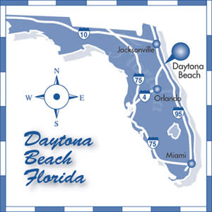
Driving to the Daytona Beach area is easy, as two of the state's major interstates intersect here - Interstate 95, which runs north and south, and Interstate 4, which comes from the west. Other major roads leading into the area include U.S. Highway 1, U.S. Highway 92, State Road 40, which connects to Interstate 75, and Highway A1A, which runs along the beautiful Atlantic coastline.
Fort Lauderdale/Miami to Daytona Beach
From Fort Lauderdale or Miami, take Interstate 95, North. Take exit numbers 261A through 273. Go east to reach the beachside areas.
Tampa and Orlando to Daytona Beach
Take Interstate 4 from Tampa or Orlando heading east. Take exit number 132A and go north on Interstate 95. At exit number 261A, take U.S. 92 / International Speedway Blvd. east to A1A and the beaches.
Jacksonville and St. Augustine to Daytona Beach
Head south on Interstate 95 to exit number 216A and head east on US-92 / International Speedway Blvd. to AIA and the beaches.
Distance to Daytona Beach from:
- Orlando, 54 miles
- St. Augustine, 62 miles
- Kennedy Space Center, 63 miles
- Jacksonville, 95 miles
- Tampa, 139 miles
- Fort Lauderdale, 230 miles
- Miami, 254 miles


